Wallowa-Whitman National Forest
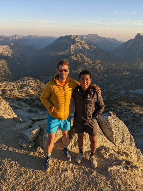
Dave (l) and Dan looking northwest from the Eagle Cap Summit
August 2021
My friend, Dave Harmon and I had run into snow and turned back early from our off-trail summit of Granite Peak, the high point of the state of Montana. Earlier in the month, I had damaged the cartilage and bone in my left knee and was in the process of getting the injury diagnosed. Despite turning back early, my knee had swollen up. Later, when I was given the option for surgical repair, this experience helped me come to accept the risk, uncertainty, and recovery time of knee surgery. I had to give myself the opportunity to enjoy nature on foot for at least a few more years.
August 2022
I had a meniscal repair and osteochondral allograft transplantation in February 2022. After months of slow, but steady recovery, I was finally back to doing some running and able to join another backpacking trek with Dave. This year, Dave cooked up another challenging itinerary, three days and two nights in the Eagle Cap Wilderness of Eastern Oregon.
- Day 0: Enterprise, Oregon
- Day 1: Wallowa Lake Trailhead to Moccasin Lake
- Day 2 (Sunrise Hike): Moccasin Lake to Eagle Cap Peak
- Day 2: Moccasin Lake to Sky Lake
- Day 3: Sky Lake to Two Pan Trailhead
Day 0: Enterprise, Oregon
About five and a half hours immediately east of Portland, Oregon is the town of Enterprise. Mostly on I-84 through the Columbia River Gorge, the drive shows off a sliver of the unique geography shared by Oregon and Washington.
A small, but surprisingly walkable town, we stayed the night in Enterprise before beginning our trek. After our drive, Dave and I enjoyed food and brews on the lawn seating of the Terminal Gravity Brewpub.
The next morning, we grabbed coffee from the charming Arrowhead Chocolates in Joseph, the town south of Enterprise. This works well if you’re using the Wallowa Lake Trailhead and don’t mind a bit of a later start as Arrowhead doesn’t open until 8am.
The town of Joseph, Oregon is named after Hin-mah-too-yah-lat-kekt, popularly known as Chief Joseph, of the Wal-lam-wat-kain (Wallowa) band of Nez Perce (Wikipedia). It should be noted that the Wallow band of Nez Perce were displaced by the US military from the Wallowa Valley in 1877.
Day 1: Wallowa Lake Trailhead to Moccasin Lake (15mi/24km, 4000ft/1219m of elevation gain)
We took the West Fork Wallowa Trail (1820) from the US Forest Service Wallowa Lake Trailhead. The trail climbs consistently adjacent to the West Fork of the Wallowa River to Six Mile Meadow where it flattens for about a mile before continuing to ascend past Frazier Lake to Glacier Lake. We ate lunch at Frazier Lake (about mile 10) after which, the climb up to Glacier Lake is pretty exposed. After enjoying the views from Glacier Lake, we ascended to Glacier Pass, the high point of our day (8400 ft/2560m).
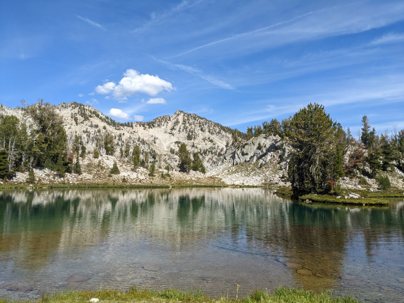
Glacier Lake
The net 1000ft/304m descent at the end of the day down from Glacier Pass to Moccasin Lake, was pretty tough. Early on this descent, I started to notice the area behind my left knee which would swell prior to my surgery. No swelling, but enough sensation to fuel fatigue-enhanced anxiety.
After a long day, we set up camp, jumped in Moccasin Lake, ate, and spent a few minutes enjoying our surroundings before falling asleep.
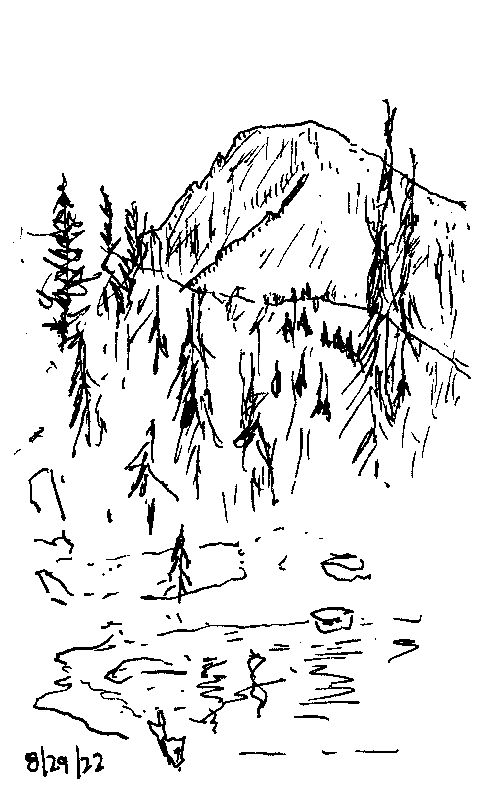
I did a quick sketch of Eagle Cap from Moccasin Lake after eating dinner.
Day 2 (Sunrise Hike): Moccasin Lake to Eagle Cap Peak (6.5mi/10km, 2000ft/609m elevation gain)
After a surprisingly warm night of restless sleep, we woke up at 4am and hit the trail taking only some food, water, rain gear, and warm clothing. Anxiety about my left knee laced my fitful sleep, but I was a little surprised and very relieved to find my knee was unswollen and ready for another day of adventure.
For the first hour or so, the stars were wonderful company and we hiked by headlamp light on the Moccasin Trail and Lakes Basin Trail to the junction with the Ivan Carper Trail and shortly after the junction with the East Eagle Trail and past Upper Lake (a relatively flat 1mi/1600m). The East Eagle and subsequently Eagle Cap Summit Trail were far from flat, but the grade was manageable and conditions were warm, windless and we were able to turn off our headlamps for the remainder of our ascent.
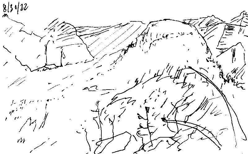
I did another quick sketch from looking southeast from the Eagle Cap summit.
At the summit, we ran into a couple of other summit-seekers and enjoyed an unspoiled view of the north and eastern part of the range, an awe inspiring sight! Our descent was uneventful and fueled by a desire for a hot coffee and breakfast. My left knee felt fine which further silenced my earlier anxiety after the prior afternoon’s rocky descent.
Day 2: Moccasin Lake to Sky Lake (14.5mi/23km, 3200ft/975m elevation gain)
After some protein powder enriched oatmeal and instant coffee, we broke camp at Moccasin Lake and hit the trail again. We had a big day planned: 16 miles/25km and 3000ft/914m elevation gain to take us from Moccasin Lake up to Ivan Carper Pass (8500ft/2590m), past Minam Lake down to the junction of the Minam Lake and Copper Creek Trails (6500ft/1981m), up to the junction with the North Minam Trail (1675, 8500ft/2590m), and finally down past Swamp Lake to Steamboat Lake (7400ft/2255m).
Despite the earlier miles and intermittent sleep, I felt good: my knee was handling the load and my anxiety lifted. On the Copper Creek Trail (1656), below Sky Lake, we were treated to a beautiful alpine meadow.
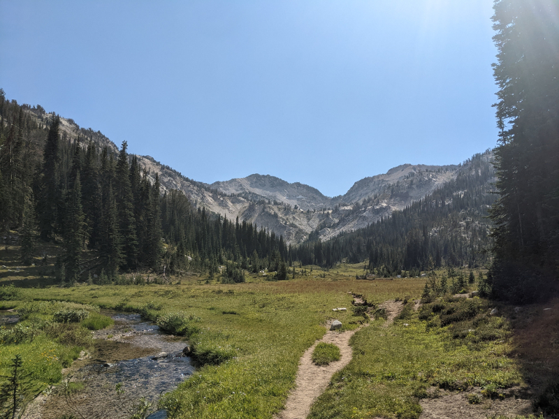
Elkhorn Creek Meadow below Sky Lake
Above the meadow and Sky Lake, near the junction of the Copper Creek and North Minam Trails, we spotted yet another awe inspiring sight, a pyrocumulonimbus cloud, a forest fire-produced cloud high above the range in our direction of travel. Already pretty tired, we decided to cut our planned itinerary short to camp near the ridge and monitor the situation.
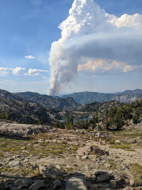
A pyrocumulonimbus cloud above Swamp Lake
While on the ridge, we had the good fortune of running into another pair of hikers taking in the spectacle: Mitsy and Eli. They helped confirm our fears: both our planned and most reasonable alternate routes were closed off by the fire. They also agreed to give us a ride back to Enterprise from the Two Pan Trailhead where they were parked. After some deliberation, Dave and I decided a much longer alternate route was off the table for our third and final day, instead, we would hike out and ride back to Enterprise with Eli and Mitsy. In case the situation changed, Dave and I hiked back down to the alpine meadow we had admired earlier and set up camp near Mitsy and Eli.
It had been a full couple of days. I felt a mix of sadness and relief that we’d be cutting our trek short. I was too tired to do a drawing from the meadow, but it was a beautiful place to rest. We were treated to another view of the pyrocumulonimbus cloud, further confirming our decision to change plans.
Day 3: Sky Lake to Two Pan Trailhead (6mi/10km, minimal elevation gain)
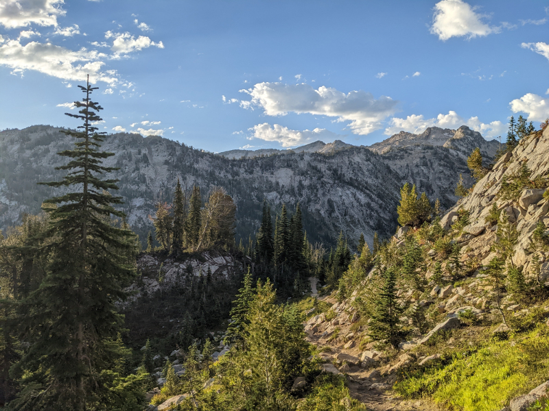
Looking south towards Minam Lake along Copper Creek
Starting at 7800ft/2377m and ending at 5600ft/1706m, we followed the Copper Creek and Minam Lake Trails down to the Two Pan Trailhead. We were pleasantly surprised to find the Minam Lake Trail below the Copper Creek Junction was quite pretty, featuring the crystal clear Lostine River. After two very long days, our downhill morning hike passed quickly and felt like a good transition back to “normal” life. I also enjoyed our ride back to Enterprise with Mitsy and Eli. It was fun to learn about Eli’s work as a hiker, author, and photographer including his work on “Hiking the Pacific Crest Trail: Oregon.”
Day 4: Writing from Home
While on the trail and now at home, my mind bounces between joy, confusion, and guilt when I try to find meaning in the opportunities I’ve had to experience natural spaces and the path of injury, surgery, and recovery I’ve traveled. My thoughts become more settled as I try to make meaning by sharing these experiences.